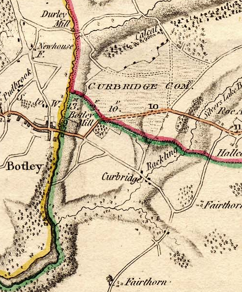
Curdridge mapped – Milne’s Hampshire, 1791.

I wrote before about the Curdridge Common Inclosure Map of 1856. That set me thinking that it might be interesting to look at other old maps of Curdridge to see what changes there have been.

The first map I found with any useful detail was Thomas Milne’s Map of Hampshire of 1791, surveyed at roughly one inch to the mile. (The coloured bands dissecting the map into three are parish boundaries).

The first thing I noticed was that Curdridge is nowhere to be seen and Curdridge Common is instead attributed to Curbridge. Furthermore, Shawford’s Lake stream and the River Cur have been merged so that there’s only one tributary flowing into the Hamble on the map rather than the actual two. There are also two Fairthorn’s on the map – and neither of them are in the right place. At that time there was only Fairthorne Farm on the way to Curbidge.

However, those errors aside, if we can rely on the roads, we can see that the Botley to Kings Corner/Pinkmead road splits as now, one road down to Curbridge and beyond and the other to the top of Kitnocks Hill and on the way to Shedfield. The road which goes North-East from the top of Kitnocks Hill, along the edge of the Common until it meets another such road coming in from the left, must be what is now Lockhams Road. The road coming in from the left and the road carrying on to the top-right edge of the map is Curdridge Lane. The thing to notice is that there was no Bishops Waltham road at this time. Curdridge Lane, via Waltham Chase, was the only way to go. This was undoubtedly because Curdridge Lane skirts the boundary to the Bishop’s Deer Park – the Park Lug, unlike the later road, which runs more directly to Bishops Waltham by going straight through the Lug and across the Park. Calcot lane, Netherhill and Wangfield Lane seem to be present, but Durley Mill is not quite where it should be. It seems to me there may have been some confusion between Wangfield Lane and the end of Blind Lane/Breech Hill (off Calcot Lane).

Meanwhile, in the centre of the map, is Curdridge Common – and a couple of tracks across it. There seem to be some houses along its Northern edge and perhaps some down a misplaced Outlands Lane. There is certainly a cluster of buildings in Curbridge. Perhaps that cluster explains the lack of a Curdridge on the map. Perhaps at that time Curbridge was a more noticeable settlement – at the crossing of the River Cur – while Curdridge was just a scattering of dwellings around the edge of the wild and uncultivated Common.

Kevan Bundell

Flying the Tiger

In writing Learning to Fly (above)[1] I failed to mention that my original desire had not actually been to learn to fly, but rather to go for a flight in an old, open cockpit biplane – a Gypsy Moth or Tiger Moth perhaps. It was while exploring the possibilities for that adventure that I discovered Solent Flight not three miles away and that I could fly there a great deal more for a good deal less per hour – even if only in a modern microlight and not in a biplane. Of course after thirty hours of lessons it cost me substantially more than if I’d stuck to my original plan of an hour in a Moth, but it all turned out for the best in the end, as I am about to tell.

It was my 70th birthday. I was looking forward to an untroubled and gentle decline into older age. There was nothing on my bucket list left to be done and, apart from one or two niggles, I was content with my lot. Then my kids announced that they were going to buy me a flight in a biplane by way of a birthday present. I had quite forgotten, but they had not !

I booked my flight at Tiger Moth Training Aviation School, based at Henstridge Airfield in Somerset.[2]

Henstridge is not so far from where my brother lives, so on the appointed day and hour a party of us – brother, sister-in-law and my wife – arrived at the airfield, me to fly, them to watch me fly. The sun was shining and the clouds were few. Unfortunately the wind was blowing perpendicular to the line of the runway and in intermittent gusts. In the old days, explained Annabelle – my instructor – these planes were flown from an open field so could take off whichever the way the wind was blowing. But here we had to use the runway and a gusty cross-wind was not helpful. It was decided it would be better to fly another day. Still, as I was there, Annabelle had me sit in the cockpit and took me through the Moth’s controls, while Clive, her colleague, took the others round the outside of the airplane.

The De Haviland DH 82 Tiger Moth was built in the 1930s and into the 1940s. It was widely used by the RAF and others as a basic trainer until it was replaced by the De Haviland Chipmunk in the early 1950s. Many are still flying, having been restored to airworthy condition, like the Moths at Henstridge. The fuselage is constructed from steel tubing and covered variously with fabric and thin plywood. The wings and tail plane are made of timber and covered with fabric. The wings are held in place by struts and steel cables. The twin cockpits are open, each protected by a modest windshield.

These are the controls of one of Tiger Moth Training’s aircraft :

Photo By Maxwell Williams – https://www.largescaleplanes.com

At first scrutiny, and compared to my familiar microlight, it was cluttered and confusing. But I soon realized that much was the same. Some dials were at a crazy angle, the compass was horizontal instead of vertical and the connecting rods from various levers were on view rather than hidden away, but otherwise they were known items.

An interesting one was the lever-with-knob on the right. It operated a couple of leading-edge slats/slots on the top wing to be employed in take-off and landing. These are instead of trailing-edge-of-the-wing flaps for the same purpose on other aircraft, such as the microlight.

Having completed the familiarization, I asked Annabelle and Clive, what are cheescutters ? Readers of Learning to Fly may recall that in a book I once read concerning learning to fly a Tiger Moth the author was repeatedly complaining about the cheesecutter, without ever explaining what it was. Having decided it probably didn’t refer to the hat of the same name, Clive guessed it might refer to the wires that go from the lever to operate the slots – like cheese wires. I have since re-read the complaints and I reckon Clive was close. I think the writer was actually referring to the slots themselves as he kept forgetting them on landing.

I returned to Henstridge alone a couple of days later in more amenable weather and Annabelle took me up. Once sufficiently airborne, she handed over control to me. Flying the Tiger proved to be both easy and problematic. The gentlest touch on the stick and rudder pedals was sufficient. But it was hard to be gentle enough. Easy to fly, hard to fly well – a well-known feature apparently, which made it a good trainer. Annabelle was (mostly) very kind – except when I overdid the throttle on one occasion, what with the engine being sixty years vintage and all. She was a fine instructor, first showing and telling, then handing the plane over to me to try myself. She (the plane) cruised straight and level quietly – although I kept having to apply rudder to counteract the rightward yaw caused by the direction of spin of the propeller – another well-known feature of the Moth. She turned, wings steeply over, in the tightest circle. She wouldn’t fly sideways though, as the microlight will, insisting on keeping her nose pointing ahead and therefore blocking my view of the countryside forward. She wouldn’t stall like the microlight either. Bring the revs down, pull hard back on the stick. Instead of the nose dropping – requiring throttle-up to recover – her nose just bobbed in front of me.

I couldn’t get a view ahead, but I could enjoy the patchwork fields and farms and villages of the Blackmore Vale to left and right. Even better, I was in an open cockpit between two pairs of wings, with struts and wires – and a mechanical windspeed indicator one of the port side struts. I tried leaning my head out beyond the protection of the windshield. I had a helmet on, but no goggles. No problem. It was windy, but not uncomfortable. But then we were only doing about sixty mph airspeed.

Tiger Moth Flight Adventure

Photo : https://www.key.aero/article/tiger-moth-flight-adventure

Having had my fun, I asked Anabelle to loop the loop for me. The maneuver was over so quickly I wasn’t sure exactly what had happened, but apparently we did indeed loop.

After a full hour airborne Anabelle brought us in to land. Clive greeted us on arrival. ’Ere, I said, we’ve only been up five minutes ! He was kind enough to laugh.

Me in the Moth. Note Annabelle despairing in the rear cockpit.

*


  1. https://www.bb.misssponto.me.uk/birdswildlifeplaces/birds-wildlife-places-introduction/learning-to-fly/ ↑

  2. https://www.tigermothtraining.com/ Image : Copyright © 2024 Tiger Moth Training. ↑

Aberlady Bay

According to an informant, the primary school children of Aberlady used to say that the village’s name was in fact A bare lady, and they had a story to explain why. But then they would, wouldn’t they ?! Actually, it probably refers to the fact that it sits beside the estuary or mouth of the river once known as the Leddie.

According to the Rev. John Smith, writing in 1845, ‘Aberlady does not appear to have been ever the scene of any very memorable event, nor is it famous in history as the birth-place, or place of residence, of any very eminent man.’ [1] However, as my Professor and friend, the late Colwyn Trevarthen, lived there, I hereby up-date Rev. Smith’s conclusion.[2]

Aberlady is in the Scottish County of East Lothian, on the southern shore of the Firth of Forth, about 17 miles by road east of Edinburgh. The estuary of the river – now called the Peffer Burn – is otherwise known as Aberlady Bay and was Britain’s first local nature reserve, established in 1952. It is also part of the Firth of Forth site of Special Scientific Interest owing to both its wildlife and its geology.

Among the wildlife are great flocks of wintering greylag geese (Anser anser) which roost on the bay and around its edges. One winter evening we watched them arrive. They first appeared as a pattern of lace across the sky, a multitude of constantly shifting lines and V formations. Once above the bay, they descended rapidly by tipping the air from under their wings, rolling first one way and then the other, until they were all settled on the low-tide sands.[3]

My most recent of many visits to Aberlady and the Bay was in early 2025. I walked out from the village to Killspindie Golf Course and to Aberlady Point, where I sat on the bladder-wrack covered rocks to eat my picnic lunch. On my way there the Bay didn’t disappoint. The tide was out, leaving ample mud and sand between the creeks for both ducks and waders : groups of teal and widgeon, random shelduck, curlew, oystercatchers, redshank – and a gather of grey plover, with their soulful eyes and neat plover bills, quite unlike other waders. They flew off as I drew nearer, though still at some distance, revealing the diagnostic black patches under their wings. There were also crows, mallard and gulls of course, but they didn’t quite provide the interest of the others– at least, not yet.

The dark ribs of abandoned boats protruded from the mud here and there. Aberlady once served as the port of Haddington, five miles inland, and was visited by substantial vessels unloading timber, manure, bark for tanning, and even whale products. But this was in the middle ages. The current remnants are probably from 19th or early 20th century fishing vessels. A combination of good timbers and salt water seem to be an excellent recipe for preservation.

Sat on the rocks, enjoying my picnic, I found myself accompanied by a crowd of ‘gnats’. Happily, they were not Scotland’s notorious biting midges. Too early in the year for them, but a good time of year, I thought, for these tiny insects to emerge – too early for swallows, and nothing else I could think of that might feast on them. A minute or two later a black-headed gull flew onto view, performing curious, aerobatic maneuvers. It was flipping and flapping and grabbing at the air. It was, I realized, attempting to catch small (invisible to me) flying insects.

I also found a tiny beetle in my picnic bag. Now where had that come from ? Perhaps I had brought it with me.

I finished my picnic and headed back to the shore. As I stood up I heard a continuous, low roaring behind me which had not been there as I sat on the rocks. An aeroplane ? A fast boat ? Neither. It continued without either fading or getting louder and there was nothing to be seen. Eventually I worked it out – it was the sound of waves breaking on Gullane Sands, far across the bay.

*

  1. https://www.aberlady.org/history/ ↑

  2. https://en.wikipedia.org/wiki/Colwyn_Trevarthen ↑

  3. They could have been pink-footed geese (Anser brachyrhynchus) it seems, but all agreed at the time – many years ago – that they were greylag. Both are available on the Bay. ↑

The Inclosure of Curdridge Common, 1856.

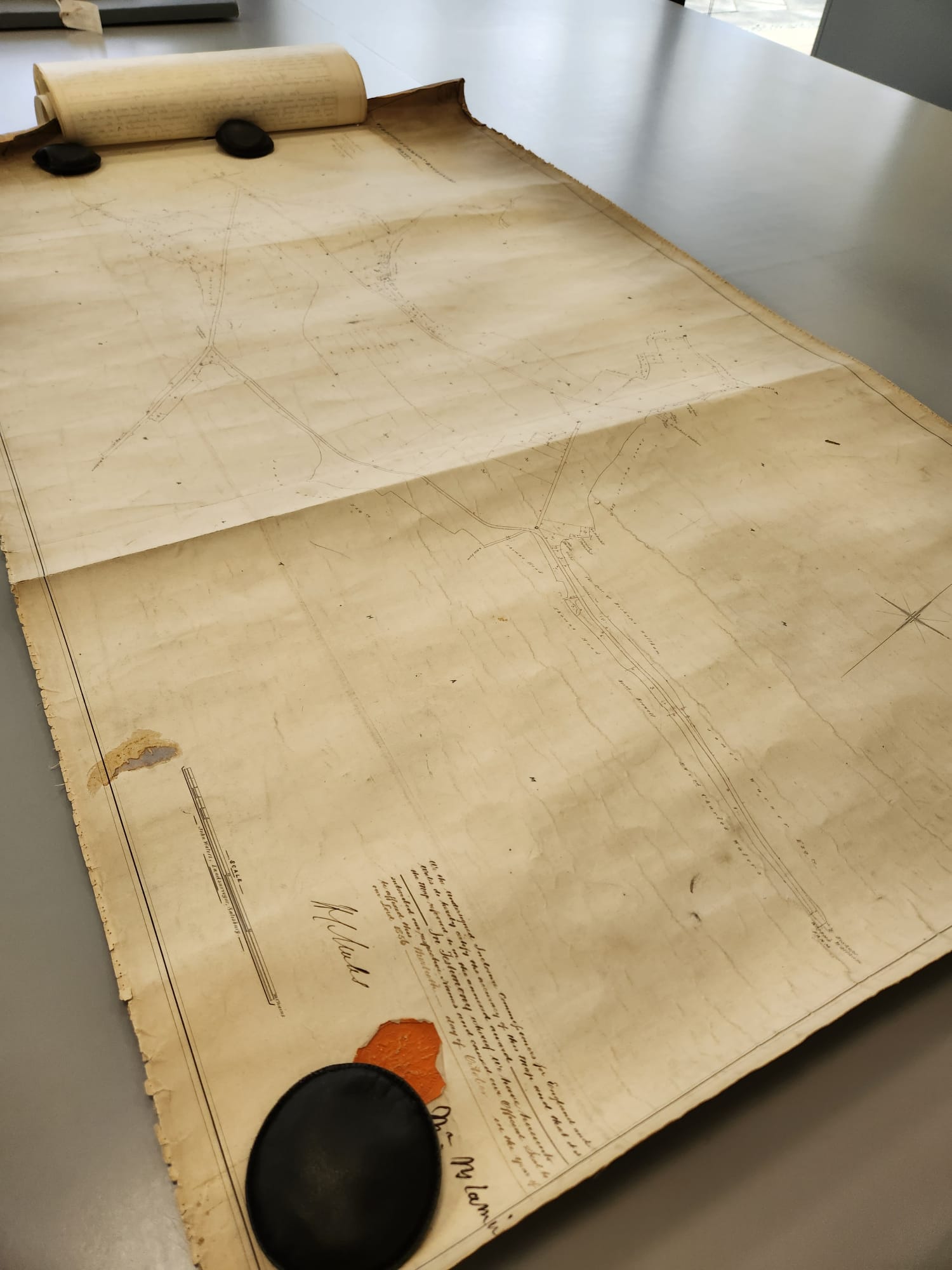
Ordnance Survey maps call the fields between Chapel Lane and the Reading Room Rec Curdridge Common. I have never heard anyone use this name for these fields, but they are indeed part of what was Curdridge Common, which extended from Lockhams Road to the top of Station Hill, bounded, more or less, by the Bishops Waltham and Shedfield roads.

Some years ago, Dennis Stokes of the Botley and Curdridge Local History Society and I were sorting through the contents of the Reading Rooms safe when we came upon a copy of the Curdridge Common Inclosure Map 1856. It was rolled up in a long metal map case and measured about 3 by 5 feet. Attached to the map were pages listing the plots the Common was divided into and to whom they were given, sold or otherwise allocated. We deposited it, along with much else, at the Hampshire Records Office in Winchester.

Most villages had a common where locals could, for example, graze their family cow or their geese and collect fallen wood and furze for their fire. The common could make an important contribution to the livelihood of the poor. How important Curdridge Common was to anyone in 1856 – a relatively late date for inclosure – I don’t know. (Inclosure, by the way, is the legal term for the enclosure of common or ‘waste’ land).

Recently, I re-visited the Records Office to take a proper look at the Map and its attachments. I looked first for my property, at the bottom of Outlands Lane, but it was beyond the bounds of the map. However, the plot where Camper House now stands, about a third of way down the lane, was on the map and was listed as being owned by William Camper – who also built my house. He was one half of the famous yacht-building firm of Camper and Nicholson of Gosport.

Here are some of my other findings :

The Reading Rooms and Rec field went to ‘John Gatery’ of South Stoneham. In other words, it did not become a public space in 1856, and indeed the Reading Room Charity was only formed in 1884 when the land was bought for £945 by Sir Henry Jenkins of Botley and the Burrells of Fairthorne Manor for the purpose of providing the Reading Room and the Rec.

The Allotments/Rec field on the Bishops Waltham road went to the Churchwardens, who were responsible for the running and up-keep of the Parish Church. This would have been the Chapel of Ease, built in 1835. The present St Peter’s was not built until 1887, when the Chapel was demolished.

The Glebe field – beside the Church car park – went to the Churchwardens and to the Overseers of the Poor to support the National School, that is, the primary school, built in 1839. The Overseers – often the same people as the Churchwardens – were traditionally responsible for organising poor relief as part of the Poor Law system.

The triangle of land now between the Plantation and the Bishops Waltham road went to the Church Wardens for ‘exercise and recreation.’ This was the site of the original village cricket pitch – and the cottage beside the pond – Cricketer’s Pond -was the original Cricketer’s Pub.

The triangle of land between the B3051 and the A334 on the Botley side of the allotments/rec, plus the land on which Blenheim Cottage now sits at the top of Station Hill, went to the ‘Incumbent’, that is, to the Vicar, as a means of raising income, probably through renting the land out.

Meanwhile, Plot 28, which appears in the list of allocations but I couldn’t find on the Map, went to the Bishop of Winchester as ‘recompense for land lost’.

The Map also shows three ponds in the village. One is Cricketer’s Pond on the Bishops Waltham road, another is the pond now within the curtilage of Curdridge Grange – apparently known as Heart in Hand farm in 1856 – on Curdridge Lane. The third has vanished. It was located at ‘Wangfield Green’, that is, opposite Lower Wangfield Farm, near Frogmill Track on Wangfield Lane.

Kitcocks House, at the top of Kitnocks Hill, is named on the Map as Curdridge House, as it is on the OS map of 1868. Curdridge House is now the name of a fine old building on the Bishops Waltham road. I wonder if anyone knows how and why the name moved ?

Interestingly, despite the enclosure, a History of the County of Hampshire of 1908 reports that at that time ‘Curdridge Common’ consists of a few fields with patches of furze and heath, sloping up from the road opposite the church’. These fields are now thoroughly cultivated, but I wonder if remnants of the Common may not still exist. The green-winged orchids in the Glebe Field (there are some in the Rec too when they’re not mown), and the few furze/gorse bushes on Reading Room Lane could be such remnants. A botanist friend from the Wildlife Trust noticed a tiny, dwarfed heather plant in among the grass as we sat on the mowed lawn at Beechcroft. He could hardly contain his excitement at the possibility that this was also a remnant from the Common.

Does anyone else know of any possible remnants ?

Kevan Bundell
www.bundellbros.co.uk

The Inclosure of Curdridge Common, 1856.

Ordnance Survey maps call the fields between Chapel Lane and the Reading Room Rec Curdridge Common. I have never heard anyone use this name for these fields, but they are indeed part of what was Curdridge Common, which extended from Lockhams Road to the top of Station Hill, bounded, more or less, by the Bishops Waltham and Shedfield roads.

Some years ago, Dennis Stokes of the Botley and Curdridge Local History Society and I were sorting through the contents of the Reading Rooms safe when we came upon a copy of the Curdridge Common Inclosure Map 1856. It was rolled up in a long metal map case and measured about 3 by 5 feet. Attached to the map were pages listing the plots the Common was divided into and to whom they were given, sold or otherwise allocated. We deposited it, along with much else, at the Hampshire Records Office in Winchester.

Most villages had a common where locals could, for example, graze their family cow or their geese and collect fallen wood and furze for their fire. The common could make an important contribution to the livelihood of the poor. How important Curdridge Common was to anyone in 1856 – a relatively late date for inclosure – I don’t know. (Inclosure, by the way, is the legal term for the enclosure of common or ‘waste’ land).

Recently, I re-visited the Records Office to take a proper look at the Map and its attachments. I looked first for my property, at the bottom of Outlands Lane, but it was beyond the bounds of the map. However, the plot where Camper House now stands, about a third of way down the lane, was on the map and was listed as being owned by William Camper – who also built my house. He was one half of the famous yacht-building firm of Camper and Nicholson of Gosport.

Here are some of my other findings :

The Reading Rooms and Rec field went to ‘John Gatery’ of South Stoneham. In other words, it did not become a public space in 1856, and indeed the Reading Room Charity was only formed in 1884 when the land was bought for £945 by Sir Henry Jenkins of Botley and the Burrells of Fairthorne Manor for the purpose of providing the Reading Room and the Rec.

The Allotments/Rec field on the Bishops Waltham road went to the Churchwardens, who were responsible for the running and up-keep of the Parish Church. This would have been the Chapel of Ease, built in 1835. The present St Peter’s was not built until 1887, when the Chapel was demolished.

The Glebe field – beside the Church car park – went to the Churchwardens and to the Overseers of the Poor to support the National School, that is, the primary school, built in 1839. The Overseers – often the same people as the Churchwardens – were traditionally responsible for organising poor relief as part of the Poor Law system.

The triangle of land now between the Plantation and the Bishops Waltham road went to the Church Wardens for ‘exercise and recreation.’ This was the site of the original village cricket pitch – and the cottage beside the pond – Cricketer’s Pond -was the original Cricketer’s Pub.

The triangle of land between the B3051 and the A334 on the Botley side of the allotments/rec, plus the land on which Blenheim Cottage now sits at the top of Station Hill, went to the ‘Incumbent’, that is, to the Vicar, as a means of raising income, probably through renting the land out.

Meanwhile, Plot 28, which appears in the list of allocations but I couldn’t find on the Map, went to the Bishop of Winchester as ‘recompense for land lost’.

The Map also shows three ponds in the village. One is Cricketer’s Pond on the Bishops Waltham road, another is the pond now within the curtilage of Curdridge Grange – apparently known as Heart in Hand farm in 1856 – on Curdridge Lane. The third has vanished. It was located at ‘Wangfield Green’, that is, opposite Lower Wangfield Farm, near Frogmill Track on Wangfield Lane.

Kitcocks House, at the top of Kitnocks Hill, is named on the Map as Curdridge House, as it is on the OS map of 1868. Curdridge House is now the name of a fine old building on the Bishops Waltham road. I wonder if anyone knows how and why the name moved ?

Interestingly, despite the enclosure, a History of the County of Hampshire of 1908 reports that at that time ‘Curdridge Common’ consists of a few fields with patches of furze and heath, sloping up from the road opposite the church’. These fields are now thoroughly cultivated, but I wonder if remnants of the Common may not still exist. The green-winged orchids in the Glebe Field (there are some in the Rec too when they’re not mown), and the few furze/gorse bushes on Reading Room Lane could be such remnants. A botanist friend from the Wildlife Trust noticed a tiny, dwarfed heather plant in among the grass as we sat on the mowed lawn at Beechcroft. He could hardly contain his excitement at the possibility that this was also a remnant from the Common.

Does anyone else know of any possible remnants ?

Kevan Bundell
www.bundellbros.co.uk

Press-ganged in Winter – the Thames again, and the Grand Union Canal.

At the end of September 2024 the heavens opened, the Thames flooded, and the river was closed to traffic. My friends Paul and Mary managed to make it to Abingdon where they abandoned ship – their mini narrow boat. They left it looped to scaffold poles driven vertically into the bed of the river so the boat could rise and fall with the waters and neither sink nor float away.

Come November Paul found time to rescue the boat and sail it to its home moorings some way up the Gand Union Canal at Castelthorpe, not far from Milton Keynes in Buckinghamshire. Unfortunately he need someone to assist and I was press-ganged into service.

Now I have sailed with him on the Thames before, but that was in Summer. This was in November and the boat had no heating. That was for fun. This was with the serious purpose of getting the boat home as quickly as possible. When they abandoned the boat at Abingdon Paul and Mary would have driven home in hardly more than an hour. At other times of year Paul and I might have sailed back via the Oxford Canal in about a week. However, the Oxford Canal was closed for Winter lock repairs so we were obliged to take the long way round. This meant descending the Thames as far as Teddington Lock, where the tidal Thames begins, pausing for slot to pass through, sailing quickly down to Brentford and entering the Grand Union Canal to head North. We arrived at Castlethorpe eighty miles and another seven days later. Altogether we sailed for twelve days and travelled one hundred and sixty miles. And – just to remind you – it was November and the boat had no heating.

It was particularly chilly on the water. Even our modest few knots sent icy tendrils past my snood and down my neck. The autumn seemed more advanced on the trees along the river banks than those I’d driven by on the way up to Abingdon. The river was still flowing strongly. As we made ready to leave, a flotilla of grey-lag and domestic geese swept down using their feet as rudders held out behind. No need to paddle.

Our journey on the Thames was dominated by bridges, increasingly posh buildings, and locks of course. Fortunately the locks on the Thames are all electrically powered. You only haves to work out which buttons to press, and in which order, to open, fill, empty and close them. Still, even that was a challenge as no sooner had I got used to one arrangement than the next lock had a different layout of buttons. The journey on the Grand Union was all locks, all of which are manual and there are lots of them. But more of that later.

*

First, bridges. We began our journey at Abingdon Bridge – or rather, bridges.


There’s an island in the steam at this point and the bridge shown is generally known as Burford Bridge, while the bridge on the other side is Abingdon Bridge proper. Except that its more complicated than that. Apparently there are three Bridges – Hart or Town Bridge, Burford Bridge and Maud Hales Bridge – all three built in the early 15th century. They have all since been altered and re-built – including the creation of wide central arch in Burford Bridge, which replaced three medieval pointed arches. The most recent re-build was in the 1920s, which involved replacing some failing arches with concrete and then sticking the stones back on the outside. Still, some of the original remains and it’s a Grade II listed structure.[1]

*

I have a personal connection with the next bridge that caught my notice. Clifton Hampden Bridge was built – of specially fired local brick – in the 1860s by the local Lord of the Manor, Henry Hucks Gibbs. It was designed by Gilbert Scott, whose many Victorian neo-gothic constructions include the Midland Grand Hotel at St Pancras Station and the Albert Memorial. Hence the fine brickwork.

Before the bridge there had been a ferry, although the river is shallow here so that horses could usually be ridden across and cattle driven. However, the shallows seem to have been what led to the bridge being constructed. In 1862 the Lord Mayor of London was sailing ceremoniously downstream from Oxford when his boat got stuck on the rocky bottom of the Clifton Hampden reach. Weirs had to be opened upstream to release him. It all took some time and was probably very embarrassing. A few years later a new lock and weir was constructed so that the water could be kept at a navigable level. But then the horses and cows couldn’t get across. A bridge was called for. Gibbs therefore had it built, financing the whole project from his own pocket.


The Manor sits just beyond the church of St Michael and All Angels, which Gibbs also restored. As for my personal connection, my friend Terry was Head Gardener at the Manor for a number of years. The house and gardens lie above the river at the top of the cliffs, which rise on one side of the river only. They are steep, wooded and cut with diagonal paths which access the river and a boat house. Terry managed the garden, an orchard, meadows and a number of woodlands. At the same time, he noticed – by eye or by ear – every bird that flew or floated by on the river or lingered in and around the property – and beyond. We stood at the top of the cliff on one occasion and he confidently identified birds singing in the fields on the further side of the river perhaps half a mile away. This is a skill which I have long envied. However, I need do so no more because I have now cheated and installed a bird song identification app on my mobile phone.

Terry was employed by the then current Lord of the Manor, Christopher Gibbs – descendant of the bridge builder. He was a well- known London antiques dealer and had been a leading fashion and aesthetic influencer in and on the swinging sixties. He had also been a friend of the Rolling Stones. I mention this last point in order to introduce the notion of Six Degrees of Separation – which is that we are all no more than six steps away from knowing anyone else[2]. I have never met the Stones of course but I know someone who knows someone who has. And that’s only three steps. Four steps and I’ve reached The Beatles – and they’ve all met the Queen. And so on. And I’m not even famous.

*

Moulsford Bridge carries the main railway line from London Paddington to Wales and the West. It was built by Brunel, chief engineer, designer and constructor of the Great Western Railway, and completed in 1840.

It crosses the river at a rakish angle and the span of its brick arches was considered bold. However, Brunel produced other bridges of a similar design and they are all, I believe, still standing. It was built wide enough to take two lines of Brunel’s unique broad-gauge track, which had its rails an enormous seven feet apart. This was later abandoned in favour of everyone else’s more modest Standard Gauge, a mere 4ft 8 ½ inches apart.[3] However, even then the width proved insufficient when the line became that busy that it required doubling. They therefore built a second bridge very closely adjacent to the first. This means that Moulsford Bridge is in fact two bridges. Unfortunately you can’t see this from my photo so I recommend you have a look at the relevant entry in Wikipedia, where the photos are much more informative. [4]

*

Enough of bridges. Posh buildings instead :


There are many fine houses along the banks of the Thames, but this one – as we approached Reading – struck me as particularly delightful. It is clearly post-Victorian but not yet modern, which makes it Edwardian I suppose – with a touch of Arts and Crafts; and classical of course – the cupola atop the tower. The thing is, I have built similar houses myself. Not actually with bricks and mortar, but with a once popular toy construction system called Bayko.

The name comes from what it was made of – Bakelite, one of the earliest commercial plastics, most familiar perhaps from the mottled brown cases of old valve radios. Bayko components came in colours though – maroon, green and cream as well as brown, then red and white – and in a post Edwardian, not yet modern, with classical references, style. It was launched in 1934 and spread across the British Commonwealth, surviving the Second World War and calmly carrying on until 1967.[5] By then I had inserted innumerable metal rods into base-plate holes and slotted brick panels, doors, windows and classical balustrades between them, before finishing the buildings off by delicately balancing a variety of roof parts on top without dislodging brick panels below. You could only make buildings. Actually, you could only really make houses.

Then I discovered Lego . . .

*

Talking of Classical, this is the folly on Temple Island. It was originally built in 1772 as a fishing lodge for the nearby big house – not as a place of worship. It was not thought of as a folly at the time, but posterity has taken a different view. Mind you, at least this one had a practical function. Many were entirely decorative and even built as mock ruins.

Personally, I’m a Goth when it comes to grand architecture. The medieval cathedrals, the Houses of Parliament, Victorian Railway stations. In the 18th Century, the neo-Classical was all the rage and although the neo-Gothic, or Gothic Revival, challenged it mightily during the 19th century, it has never gone away. Indeed, there are a handful of neo-classical houses recently built in our rural village. This might be okay located in an extensive park landscape with lawns, meadows and trees surrounding, but not when squeezed in between other people’s homes and occupying the plot from boundary to boundary. (Yes, there has been much grumbling).

In fact, the Houses of Parliament, and many railway stations, are a mix of the two styles. The principal architect of the new Palace of Westminster, Charles Barry, was obliged to work with Augustus Pugin and have his classical plan heavily decorated with Gothic detail both inside and out. Incidentally, the building took nearly five times longer than planned to build and cost getting on three times the original estimate. Anyone would think it was a nuclear power station, or HS2.

The contemporary importance of the fishing lodge/temple/folly is that it is the official starting point of the Henley Regatta. The Regatta – a rowing competition – is one of the main events of the posh end of the English social ‘season’. It is a place to be seen and to drink Pymms. Ladies are encouraged to wear hats. Men must wear ties or cravats. Fortunately for us it takes place in July as we were dressed in heavy gauge windcheaters and I had a woollen snood around my neck.

Before you conclude from the mention of July that rowing races are for softies, we ran into the middle of a rowing event just as we approached Hampton Court Bridge – in November. We were obliged to moor up for a couple of hours until they were finished. This turned out to be a good thing. It meant I could do the only sightseeing there was time for on our journey – I visited Hampton Court Palace – and Paul could devote himself to reading without me constantly trying to start conversations on interesting topics. He was having none of that for the whole journey. We listened to interesting music instead, via his mobile phone, but only in the evenings. In the mornings he would wake me up with what he considered to be a joke – my childhood favourites, Cliff Richard (Summer Holiday !), Herman’s Hermits (I’m into something good – huh !) and the Seekers (I know I’ll never sail again with you).

At the entrance to Hampton Court I was met by a number of uniformed staff. “I last came here in about 1964”, I said. “On a Sunday School outing. It hasn’t changed a bit.” I considered this to be at least vaguely amusing. They were kind enough to smile, but then one of them – a gentleman clearly even older than me – replied that he’d first come here in 1963, on a Sunday School outing. They let me in anyway.

I headed at once for the famous Hampton Court Maze. It was the only thing I actually remembered from my childhood visit.


This is the entrance. I didn’t go in. As a child, I had gone in and found my way out again – obviously – but now, as an adult, I did not trust myself to go in and still have time to see the Palace itself. Or indeed to find my way out at all. I left the maze and entered the Palace. What struck me most about the interior was how horribly cold it must have been in Winter, and gloomy, lit only with candles and oil lamps. And this was the King’s house. Lord knows how my peasant ancestors survived. As for the exterior, in terms of architectural styles the Palace is a bit of mix. It is Tudor from the front, with its plethora of twirly brick chimneys, and Classical from the rear. It was originally built during Henry VIII’s reign in the first half of the 1500s in Tudor style. It was then altered and added to in the late 1600s by William III in the Baroque style, a classical pre-cursor of neo- Classical proper.


I preferred the front.

*

But I have got ahead of ourselves. Before we came to Hampton Court we sailed past Windsor Castle.


Architecturally speaking, the Castle has something for everyone, though fortunately the classical aspects – baroque and (worse still, rococo) are more or less confined to the interior. In any case, they do not spoil the essentially Gothic appearance of the Castle seen from the surrounding town and countryside, including from the river. This happy happenstance is the result of its many additions and extensions generally keeping to its original style even when contemporary fashions – especially Georgian and Victorian – were applied. The Castle started off as a Norman motte and bailey fortification – a mound with a keep on the top – built by William the Conqueror. It was soon expanded, and a palace added inside. It is the biggest castle in Britain and the longest royally-occupied palace in Europe.

I once stayed in Windsor Castle – I was attending a conference – in rooms above the Henry VIII Gateway, the public entrance into the Castle. The window looked out over the yard of the Lower Ward, where Guards in bearskins performed their ceremonial Changes, and stood at attention while being photographed by tourists. The uniformed gentleman-warder who led me into the rooms pointed out some scratchings on the window glass which could, with some persuasion, be interpreted as the initials AB. His story was that Anne Boleyn must have scratched them herself while awaiting her fate. A policeman at the Gate told another, probably apocryphal, tale about an American tourist who asked why the devil they’d built the castle under the flightpath to Heathrow.

Beyond the Castle the Thames runs for some distance beside The Home Park where black range rovers patrolled and stern notices forbade landing. A string of poplar trees planted along the bank were thickly festooned with pom-poms of mistletoe.

*

Before moving on to locks, I must mention the Egyptian geese we met all along the river, and moored beside, somewhere near Shepperton.

The Thames is dripping with geese along its freshwater length – greylag and Canada as well as Egyptian (Alopochen aegyptiaca). The former were in flocks, the Egyptians generally came in pairs. They are non-native of course, being originally from the Nile and all points South, as well as West across the Sahel. They were introduced into Britain as ornamentals as long ago as the 17th century, but they must have been slow to spread because they were only added to the official British Bird list in 1971. They are found mostly in East Anglia and in the Thames valley but are now considered to be threatening the Midlands. Being foreigners, they are allowed to be shot if deemed to be causing a nuisance. They are also not geese. They are most closely related to the native Shelduck, which is not a duck . . .

The Thames is a hotbed of non-native species. We also saw mandarin ducks (Aix galericulata) – another ornamental, originally from East Asia, and the ubiquitous rose-ringed parakeets (Psittacula krameri) from India which rocket and screech not only along the river but across suburban South-West London and even into leafy Surrey. Not only are they foreigners, but they were, according to urban myth and rumour, introduced by foreigners. The myth is that a pair were released by Jimi Hendrix when he was living in London – which is exciting, but without foundation. In any case, the rumour is more likely – that some folks from the Indian sub-continent kept them as pets and reminders of home and that some, inevitably, escaped.

Canada geese (Branta canadensis) are also non-native of course. They are another 17th century introduction, first to St James Park in London when a few were gifted to James ll, although some arrive under their own steam from their North American homeland. They are now spread across most of Britain and their numbers more or less match those of the greylag (Anser anser), Britain’s only native breeding goose.

*

As mentioned earlier, all the locks on the Thames are electrically powered and operate by the pressing of buttons. This was not always the case, as I recalled as we went through Cleeve Lock, just upstream from Streatley and Goring.


In the Summer of 1965, the lock-keeper at Cleeve was assisted in the opening and closing of his traditionally manual gates by my brothers and I – ages eight to eleven. We applied our mighty frames to his gates with gusto whenever we could be there. We were on a camping and caravaning holiday nearby. The lock-keeper was kind enough to pretend that we were actually helping.

*

We left the broad and shining Thames at Brentford via the Thames Lock, the beginning of the Grand Union Canal (unless you’re starting from the Birmingham end). It was at once a different world. Narrow, urban, shaded and unkempt – although some of the unkempt was delightful. Untended lock gates had become gardens.

Then we came to the Hanwell Flight. Six locks, like stairs, one after the other. Very picturesque. All manual.

But this was only the beginning. I didn’t count the number of locks we enjoyed the next day, but I did notice that we were travelling back in time, with each lock clearly dated the year or so before the previous one. The following day, from Common Moor to Boxmoor in the environs of Hemel Hempstead, we traversed seventeen manual locks. And the same again both of the next two days – plus a manual swing bridge somewhere along the way. Mary met us for lunch somewhere. We dined at The Boat public house. There was no escape. I lost count of the locks, and of their dates. Confusion set in. There was no clear order. I remember Paul announcing that we had now reached the highest point of this part of the canal and it would henceforth be downhill all the way. But I was not so addled that I didn’t know that downhill makes no difference at all in terms of getting through locks. There are still up to six sluices or paddles to raise and return by manual crank and four gates to open and close by leaning hard and pushing. And all in the correct order. Its not that I did every lock. Paul definitely did one or two. However, we agreed that it was more efficient with him in charge of the boat – as befits the Captain and more experienced sailor. Anyway, I had been press-ganged. I knew my place.

*

We finally arrived at Castelthorpe and our vessel’s home mooring on day twelve. We had confronted and overcome thirty locks on the Thames and eighty on the Grand Union. We had sailed about ninety miles on the Thames and some seventy on the Canal. We had no heating. It was November. We even had to tackle a wrecked and abandoned, fifty foot narrow boat which was blocking the canal and which I forgot to mention earlier. Best of all though, somewhere on the Thames we had the delight of a half second glimpse of the curving back of an otter.

Would I do it again ? Only if Paul fixes the heating.

*
  1. My sources for the above information are Wikipedia and the Abingdon Area Archaeology and History Society. But history is difficult. My sources differ – even as to the number of bridges, never mind the alterations. ↑

  2. https://en.wikipedia.org/wiki/Six_degrees_of_separation ↑

  3. Apparently determined by the average distance between the neck and ankles of a damsel in distress . . . (https://www.theguardian.com/notesandqueries/query/0,5753,-1533,00.html) ↑

  4. https://en.wikipedia.org/wiki/Moulsford_Railway_Bridge ↑

  5. https://en.wikipedia.org/wiki/Bayko ↑

The Matrix and me.

I saw The Matrix when it was first released. I was flying back to LHR on an overnight BA flight and it was one of that month’s newly released movies. Sci-fi – always my favourite – but different. Fast, original and, of course, visually stunning. The best since Bladerunner.

I was especially impressed by the excellent, unexpected ending:

Neo has survived, triumphed even, when suddenly the action shifts to a quite new location. Its a college classroom or gym. People are sat in a circle. They are taking their head-sets off. There are comments about what a great game it was. A couple of the players reach down to the hold-all bags under their chairs. They take out machine guns and proceed to shoot the rest of the circle. We are still in the Matrix !

Hey, you say, that’s not how it ends! It ends with Neo in a phone box wondering what he’ll do next and then doing a Superman – shooting off in to the sky.

You are correct. That is indeed how the film ends and I can find no evidence at all that the ending I saw ever existed.

So where the devil did it come from ? The usual accusation when I tell the tale is that I dreamt it. Which is quite possible. It was an overnight flight . . . But it’s an amazingly good dramatic twist-of-an-ending to make up while I’m asleep . . .

Alternatively, what if you found you wanted to make more Matrix movies ? Was this an original Director’s ending which the studio immediately cut and replaced with the phone box so that they could make Matrix 2 ?

Possibly. But I can find no evidence.

What I do notice, however, is that this is not the only occasion when I have experienced something which I clearly remember or knew to be the case in the past suddenly no longer being true in the present. These are usually quite minor items and easily dismissed as miss-rememberings, misunderstandings, mistakes. You have to be alert even to notice them, and even more so to remember them. I am alert and I do sometimes notice them. I point them out to my family when they occur. However, I cannot now remember them. I can give no examples. I am unable to. There are glitches in reality, but they escape us. This one, The Matrix’s ending, is the exception. I did not forget it.

So what are we to make of it all ? There is the obvious possibility that we exist within a ‘Matrix’. Just like the movie. The glitches in reality are up-dates, or corrections to the code.

This is not as ridiculous an idea as it might seem. Faced with the intractable absurdities of quantum weirdness, it has been suggested, as a logical possibility, that the existence of both ourselves and our world can reasonably be explained by the notion that we are living in a computer simulation created by a higher intelligence. Indeed, that we may be simulations ourselves . . .

How are we to know ? Is there any way of telling ? Perhaps there is not. But I invite you to be alert, to notice and to try to remember. The evidence is out there. We must strive to hold on to it, to know reality.

Unless it’s better not to notice, and if you do, then to forget . . .

*

NOTE : This is a true story, as you may have gathered. Apart from this Matrix incident, the other major incident I do remember is when, after many years of travelling on the London Underground, Cocksfooters – at the top end of the Piccadilly Line – suddenly became Cockfosters. Reality changed. And before that, Ticket to Ryde became Ticket to Ride. And who remembers when Abba used to sing take your teeth out, before it became Chiquitita ? (No, that’s just silly. Stop it at once). The thing is, no one else remembers. Yesterday has been quite forgotten.

St Peter’s Church and Sir Bevis of Hampton.

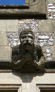
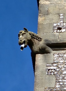
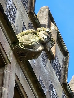
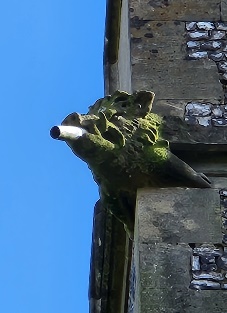
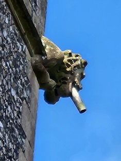
You may have noticed that the tower of St Peter’s Church is adorned around with a series of carvings of a variety of figures, some human, some animal. They are characters from the medieval legend of Sir Bevis of Hampton – i.e. of Southampton. Bevois Valley, south of Portswood, is named after him. The legend is long and complicated and if you want to know the details you can find them at https://historicsouthampton.co.uk/bevis/

 Meanwhile, it is not too difficult to match up the characters in the legend with the figures on the tower.

For a start, there’s Sir Bevis himself :   

And his horse Arondel :  


And the twins :  

and the boar :      and the lion :  

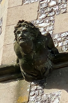
However, one of the figures is commonly said to be a character not from the Legend of Sir Bevis but rather from the local Curdridge ledgend of Kitty Knocks :

   This story tells of a young woman who drowned one night on Kitnocks Hill while trying to elope. I have written about this affair previously in the Parish News (see: https://www.bb.misssponto.me.uk/kevansmiscellany/category/kitnocks-kitty-nocks-curdridge-witch). I have even written a song about it, which you can listen to at https://www.youtube.com/watch?v=YyeD8Jf4KSU (at 18.56).

The question is, who was this character actually intended to be when they built the tower ? Was it meant to be Kitty Nocks, or was it meant to be another character from the Sir Bevis legend – Princess Josian, for example, Sir Bevis’s girlfriend ? In order to try and settle the matter, I headed off to the Hampshire Records Office in Winchester.

I found the papers – letters, documents, plans – relating to the building of St Peter’s Church in 1887. Unfortunately they had nothing to say about the tower, or its inhabitants.

It turns out that the tower was built some seven years later than the church itself – and there are no papers at all in the Records Office relating to the tower.

The mystery remains then. Is it Kitty Knocks, or is it not ?

Kevan Bundell – www.bundellbros.co.uk

Miss Lorna Bayley.

Miss Bayley joined the staff of Eastwick Primary School, I calculate, sometime in 1963/4. I remember her arrival. Suddenly things began to change in our morning school assembly. There were new ideas, new components, creative changes.

She taught my older brother Arnold in his last year at Eastwick in ‘63/4. She became my class teacher in September ’64, and remained so for two years until we left in July 1966.

She had a one-eyed Song Thrush in her garden called Nelson.

She introduced a maths-teaching tool called Colour Factor which was very modern but which I totally failed to comprehend.

It was the time of the Tokyo Olympics. She set maths questions on the board and a race to answer them, awarding Gold, Silver and Bronze stars to the winners . . . I remained starless.

However, she also got us boys gardening (the girls were busy dressmaking I think) – and she put up a bird table outside the classroom window. This was pioneering stuff. At this time feeding the birds mostly meant throwing crusts of bread out in the back garden or hanging up bacon rind. She bought proper bird feed. She put up large RSPB bird identification charts on the classroom wall and Robbie Medland and I competed to identify each bird. We thereby came to know birds which we had never actually seen – and many which I have still not seen.

Miss Balyley also encouraged my artistic leanings – drawing and painting animals and birds. She even set me up with a one-boy show of my work on the corridor wall.

She paid for me to join the RSPB, and continued to pay my subscription for some years after I had left Eastwick and moved away. We corresponded during that time, until I grew into a teenager and probably just stopped writing any more.

I did meet her once during those few years, at an Eastwick School fete in, I would guess, 1968. By this time I had been growing for a couple more years. I towered above her. As the photo of her class shows, she was really very short, only I hadn’t noticed when I was short too. Now I was an awkward thirteen year old. I don’t know what I said to her. I hope I thanked her for being so very good to me.

Shawford’s Lake, Curdridge

It has long been a puzzle to me why the stream which runs by Lake Road/ Silverlake, through Kitnocks Gully and down through Fairthorne Manor to the Hamble, is called Shawford’s Lake. It is in fact a perennial stream of very modest dimensions. It’s certainly nothing like a lake.

But it’s not the only local stream that’s called a lake – there’s also Ford Lake which joins the Hamble at the junction of Wangfield Lane and Maddoxford Lane; and there’s Posbrook Lake which joins at the old slipway on Church Lane in Botley. Just before the Hamble joins the Solent, there’s a tributary called Hook Lake.

Some while ago, I happened to be perusing the Ordnance Survey map of the Solent. I noticed that many of the tidal channels in Portsmouth, Langstone and Chichester Harbours, are called lakes. The main channel of Portsmouth Harbour is fed, for example, by Fareham, Porchester, Spider and Bombketch Lakes. Langstone Harbour is similarly blessed with Broad, Russell’s and Sinah Lakes.

There was obviously a mystery here to be explored.

I consulted my friend David Chun, expert on and author of The River Hamble: A History.  It seems that the word lake has two different etymological origins. On the one hand, our usual and modern word lake comes, via French, from Latin lacus, meaning a lake, basin or tank. There is no suggestion there of a stream. However, the now dialect word used for our tributary streams and channels comes from Germanic Anglo Saxon lacu, meaning lake, pool and also stream. These words are of quite separate origin, but, unsurprisingly, they have become, over time, conflated and confused.

Puzzle solved.

However, another puzzle remains. Silverlake – which is not obviously silver nor a lake – derives its name from Anglo-Saxon Sulaford, which means ford of/at the boggy place. It was a ford on the important road from Botley, through Curdridge, to Shedfield and on to Wickham – before it was bridged – or rather, culverted. As Anglo-Saxon gave way to Middle and so to Modern English, Sula became silver and ford was replaced with lake, referring to the stream. But then how, why and when did it then become Shawford’s Lake ?


Kevan Bundell

www.bundellbros.co.uk